Maps Site map
  FL Maps > Region > 1950-1999
Site Map  

  Record   176   to   200  of   261

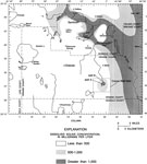
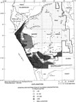
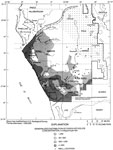
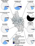
Dissolved Solids Concentrations in Water of the Upper Floridan Aquifer in the Greater Orlando Metropolitan Area, 1996
This map from the U. S. Geological Survey Water Resources Investigation Report number 96-4181, Hydrogeologic Conditions and Simulation of Ground Water Flow in the Greater Orlando Metropolitan Area, shows the generalized distribution of dissolved soli...

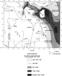
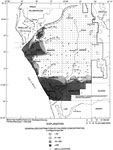
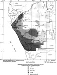
Chloride Concentrations in Water of the Upper Floridan Aquifer in the Greater Orlando Metropolitan Area, 1996
This map from the U. S. Geological Survey Water Resources Investigation Report number 96-4181, Hydrogeologic Conditions and Simulation of Ground Water Flow in the Greater Orlando Metropolitan Area, shows the generalized distribution of chloride conce...

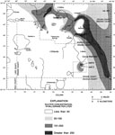
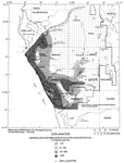
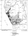
Sulfate Concentrations in Water of the Upper Floridan Aquifer in the Greater Orlando Metropolitan Area, 1996
This map from the U. S. Geological Survey Water Resources Investigation Report number 96-4181, Hydrogeologic Conditions and Simulation of Ground Water Flow in the Greater Orlando Metropolitan Area, shows the generalized distribution of sulfate concen...

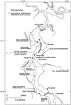
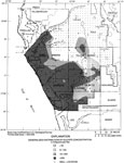
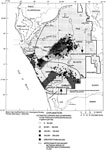
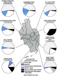
Location of Wastewater Treatment Plant Outfalls to the St. Johns River, 1996
This map from the U. S. Geological Survey Water Resources Investigation Report number 95-4257, Detection of Groundwater Discharge, shows the locations of the wastewater treatment plant outfalls to the St. Johns River between Jacksonville and Green Co...

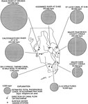
Generalized Distribution of Chloride Concentration in the Intermediate Aquifer System of West Central Florida, 1996
This map from the U. S. Geological Survey Water Resources Investigation Report number 96-4030, Potential for Water-Quality Degradation of Interconnected Aquifers in West-Central Florida, shows the generalized distribution of chloride in water from th...

Generalized Distribution of Chloride Concentration in the Upper Floridan Aquifer System of West Central Florida, 1996
This map from the U. S. Geological Survey Water Resources Investigation Report number 96-4030, Potential for Water-Quality Degradation of Interconnected Aquifers in West-Central Florida, shows the generalized distribution of chloride in water from th...

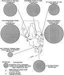
Generalized Distribution of Sulfate Concentration in the Intermediate Aquifer System of West Central Florida, 1996
This map from the U. S. Geological Survey Water Resources Investigation Report number 96-4030, Potential for Water-Quality Degradation of Interconnected Aquifers in West-Central Florida, shows the generalized distribution of sulfate in water from the...

Generalized Distribution of Sulfate Concentration in the Upper Floridan Aquifer System of West Central Florida, 1996
This map from the U. S. Geological Survey Water Resources Investigation Report number 96-4030, Potential for Water-Quality Degradation of Interconnected Aquifers in West-Central Florida, shows the generalized distribution of sulfate in water from the...

Generalized Distribution of Dissolved Solids Concentration in the Intermediate Aquifer System of West Central Florida, 1996
This map from the U. S. Geological Survey Water Resources Investigation Report number 96-4030, Potential for Water-Quality Degradation of Interconnected Aquifers in West-Central Florida, shows the generalized distribution of dissolved solids in water...

Generalized Distribution of Dissolved Solids Concentration in the Upper Floridan Aquifer System of West Central Florida, 1996
This map from the U. S. Geological Survey Water Resources Investigation Report number 96-4030, Potential for Water-Quality Degradation of Interconnected Aquifers in West-Central Florida, shows the generalized distribution of dissolved solids in water...

Areas of Potential for Contamination due to Interconnected Aquifer Wells in West Central Florida, 1996
This map from the U. S. Geological Survey Water Resources Investigation Report number 96-4030, Potential for Water-Quality Degradation of Interconnected Aquifers in West-Central Florida, shows the areas in west-central Florida where there is potentia...

Wells Open to Both the Intermediate and Upper Floridan Aquifer Systems in West Central Florida, 1996
This map from the U. S. Geological Survey Water Resources Investigation Report number 96-4030, Potential for Water-Quality Degradation of Interconnected Aquifers in West-Central Florida, shows the locations in west-central Florida of wells that are o...

Estimated Upward and Downward Flow through Open Boreholes in West Central Florida, 1996
This map from the U. S. Geological Survey Water Resources Investigation Report number 96-4030, Potential for Water-Quality Degradation of Interconnected Aquifers in West-Central Florida, shows the estimated upward and downward flow in gallons per day...

Phosphorus Loading in Surface Water Basins of Southern Florida, 1996
This map from the U. S. Geological Survey Water Resources Investigation Report number 96-4177, Water-Quality Assessment of Southern Florida, shows the estimated phosphorus loading from both point and non-point sources in surface-water basins in south...

Nitrogen Loading in Surface Water Basins of Southern Florida, 1996
This map from the U. S. Geological Survey Water Resources Investigation Report number 96-4177, Water-Quality Assessment of Southern Florida, shows the estimated nitrogen loading from both point and non-point sources in surface-water basins in souther...

Phosphorus Loading in Selected Canal and River Outflows in Southern Florida, 1996
This map from the U. S. Geological Survey Water Resources Investigation Report number 96-4177, Water-Quality Assessment of Southern Florida, shows estimated total phosphorus loads for selected canal and river outflows in kilograms per year. The map a...

Nitrogen Loading in Selected Canal and River Outflows in Southern Florida, 1996
This map from the U. S. Geological Survey Water Resources Investigation Report number 96-4177, Water-Quality Assessment of Southern Florida, shows estimated total nitrogen loads for selected canal and river outflows in kilograms per year. The map als...

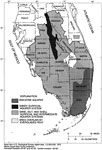
Aquifer Systems and Extent of Peat in Southern Florida, 1996
This map from the U. S. Geological Survey Water Resources Investigation Report number 96-4177, Water-Quality Assessment of Southern Florida, shows the aquifer systems in southern Florida and the extent of peat in the Everglades region. The aquifer sy...

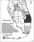
Occurrence of Hydrogenated Aliphatic Hydrocarbons from Water Utilities in Southern Florida, 1996
This map from the U. S. Geological Survey Water Resources Investigation Report number 96-4177, Water-Quality Assessment of Southern Florida, shows the number of water utilities with untreated water samples in which concentrations of halogenated aliph...

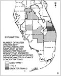
Occurrence of Monocyclic Aromatic Hydrocarbons from Water Utilities in Southern Florida, 1996
This map from the U. S. Geological Survey Water Resources Investigation Report number 96-4177, Water-Quality Assessment of Southern Florida, shows the number of water utilities with untreated water samples in which concentrations of monocyclic aromat...

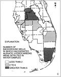
Occurrence of Hydrogenated Aliphatic Hydrocarbons from Background Wells in Southern Florida, 1996
This map from the U. S. Geological Survey Water Resources Investigation Report number 96-4177, Water-Quality Assessment of Southern Florida, shows the number of background wells in which halogenated aliphatic hydrocarbons were detected in water sampl...

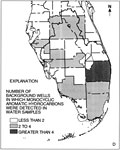
Occurrence of Monocyclic Aromatic Hydrocarbons from Background Wells in Southern Florida, 1996
This map from the U. S. Geological Survey Water Resources Investigation Report number 96-4177, Water-Quality Assessment of Southern Florida, shows the number of background wells in which monocyclic aromatic hydrocarbons were detected in water samples...

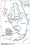
Regional Ecosystem and Watersheds of South Florida, 1996
This map from the U. S. Geological Survey Circular 1134, The South Florida Environment, shows the natural Kissimmee-Okeechobee-Everglades watershed boundary and the Southern Florida National Water Quality Assessment study unit boundary, as well as th...

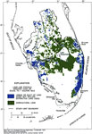
Urban and Agricultural Lands in South Florida, 1996
This map from the U. S. Geological Survey Circular 1134, The South Florida Environment, shows urban and agricultural land use in south Florida for land-use parcels greater than or equal to 1 square mile. The land use and land cover categories are bas...

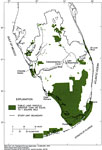
Public Lands in South Florida, 1996
This map from the U. S. Geological Survey Circular 1134, The South Florida Environment, shows the lands in south Florida under public ownership or control, including State and Federal parks, reserves, sanctuaries, and preserves....

First Previous Next Last


  FL Maps > Region > 1950-1999
Site Map  

Maps ETC is a part of the Educational Technology Clearinghouse
Produced by the Florida Center for Instructional Technology © 2007
College of Education , University of South Florida