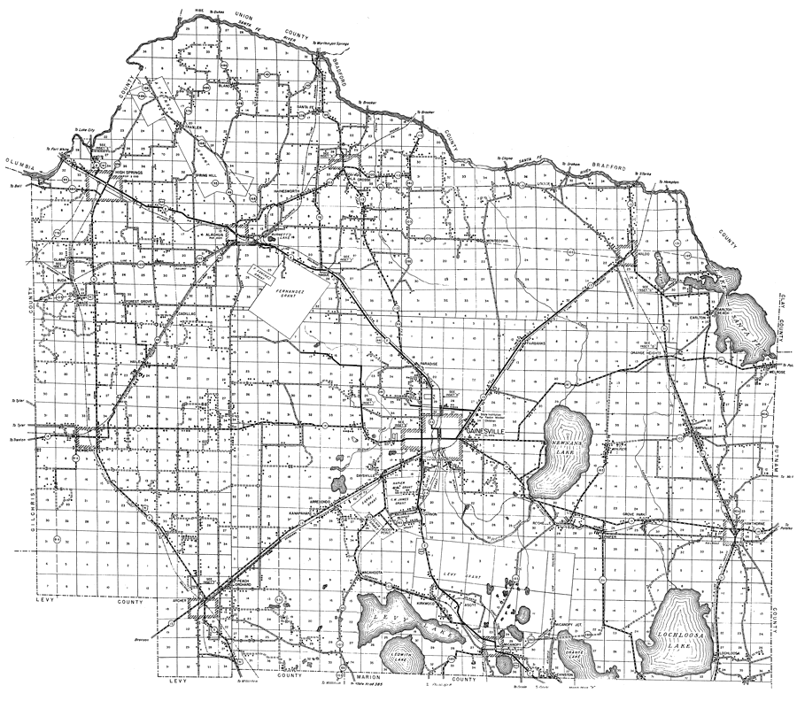
Description: This is a detailed map of the county of Alachua in the state of Florida. Section Township Range (STR) is shown. This map shows all of the main cities, state roads, US Highways, bridge highways, drawbridge highways, railroads, location of grants, inland waters, canals, corporate lines, county boundary, reservation boundary, cemeteries, churches, farm units, dwellings other than farms, tenant houses, businesses, turpentine still, townhalls, hotels, schools, hospitals, factories, sawmills, post offices, radio stations, powerplants, water tanks, airports, tourist camp, municipal park, mines and playgrounds. Key to Florida Highway maps.
Place Names: Alachua, Alachua, La Crosse, Gainsville, Fernandez Grant, F. Sanchez Grant, Archer, Levy Lake, Ledwith Lake, Lochloosa Lake, Orange Lake, Micanopy, Hawthorne, Newnans Lake, Lake Santa Fe, Lake Altho, Santa Fe River, Atkinson Grant, Kanapaha, Arrendondo, Newberry, Garnet Grant, Napier Grant, Clark Grant,Clinch Grant, McIntosh Grant, G. W. James Grant, Burnetts Lake, Levy Grant, Orange Heights, High Springs, Waldo, Rocky Point,
ISO Topic Categories: boundaries, transportation, location, inlandWaters
Keywords: Alachua, physical, political, transportation, physical features, major political subdivisions, county borders, local jurisdictions, roads, railroads, boundaries, transportation, location, inlandWaters, Unknown,1936
Source: , Florida State Road Department (, FL: , 1936)
Map Credit: Courtesy the private collection of Roy Winkelman. |
|