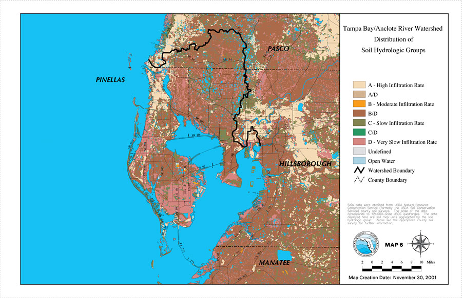
Description: This is a map from the Southwest Florida Watershed Management District or SWFWMD of the Tampa Bay/Anclote River watershed distribution of soil hydrologic groups, created on November 30, 2001. This map shows the following soil hydrologic groups: A- high infiltration rate (beige), A/D (light brown), B- moderate infiltration rate (orange), B/D (brown), C- slow infiltration rate (olive green), C/D (green), D- very slow infiltration rate (mauve), and undefined (light gray). It also shows the Watershed Management boundary shown by the thick black line, US/State roads, open water, inland water and county boundaries. "Soils data were obtained from USDA Natural Resource Conservation Service (formerly the USDA Soil Conservation Service) county soil surveys. The scale of the data corresponds to 1:24,000 scale USGS quadrangles. The data displayed here are soil map units aggregated by the soil hydrologic group. Please see the appropriate county soil survey for further information." —Southwest Florida Watershed Management District
Place Names: 2000-, counties, �Pasco, �Tampa Bay, �Anclote River, �Hillsborough, �Manatee, �Pinellas
ISO Topic Categories: boundaries, �geoscientificInformation, �inlandWaters, �transportation
Keywords: Tampa Bay/Anclote River Watershed Distribution of Soil Hydrologic Groups, physical, �political, �transportation, �hydrological, �watershed, �kwatershed, physical features, county borders, roads, boundaries, �geoscientificInformation, �inlandWaters, �transportation, Unknown,November 30, 2001
Source: Southwest Florida Water Management District, Tampa Bay/Anclote River Comprehensive Watershed Management Plan Atlas (Brooksville, FL: Southwest Florida Water Management District, 2001)
Map Credit: Courtesy of the Southwest Florida Water Management District |
|