mapsExploring Florida
 FL Maps > Region > 1840-1859 > Florida Keys: A General Reconnoissance of the Western Coast of Florida, 1851
Site Map 

Florida Keys: A General Reconnoissance of the Western Coast of Florida, 1851


Puzzle Directions: Click on a puzzle piece and drag it where you want it. When you connect two pieces correctly, they will join together. Mix up the pieces again. View finished map in pop-up window.

Title: Florida Keys: A General Reconnoissance of the Western Coast of Florida
Projection: Unknown
Source Bounding Coordinates:
W: E: N: S:

Back to Map Page
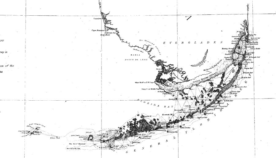
Description: A portion of a U.S. Coast Survey chart showing the southernmost point of peninsular Florida from the Miami River and Key Biscayne on the Atlantic Coast to Key West and the Dry Tortugas in the Florida Keys. The chart includes sailing directions including bearings, soundings and detailed triangulations. The map also shows the Everglades and an area of Indian hunting grounds. Included is an in-land notation describing dense forest of mangrove and pine. Surveyed by F. H. Gerdes. The map scale is 1:1,200,000.
Source: F.H. Gerdes, U.S. Coast Survey (Washington, DC: Government Printing Office, 1851)
Map Credit: Courtesy the private collection of Roy Winkelman
SearchLicensePDF HelpGIS Help Google Earth Help Zoomify Help

 FL Maps > Region > 1840-1859 > Florida Keys: A General Reconnoissance of the Western Coast of Florida, 1851