mapsExploring Florida
 FL Maps > Region > 1950-1999 > Mean Annual Rainfall in the Indian River Basin, 1951 to 1980
Site Map 

Mean Annual Rainfall in the Indian River Basin, 1951 to 1980


Puzzle Directions: Click on a puzzle piece and drag it where you want it. When you connect two pieces correctly, they will join together. Mix up the pieces again. View finished map in pop-up window.

Title: Mean Annual Rainfall in the Indian River Basin
Projection: Unknown
Source Bounding Coordinates:
W: -81 E: -80 N: 29 S: 27.3

Back to Map Page
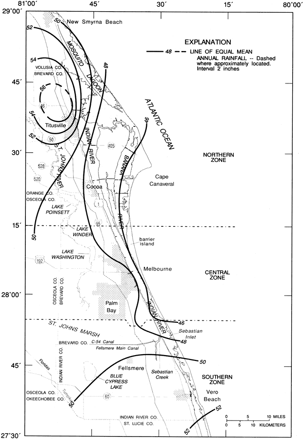
Description: This map from the U. S. Geological Survey Water Resources Investigation Report number 97-4011, Rainfall and Freshwater Discharge in the Indian River Basin, shows the average annual rainfall in the Indian River Basin from the period 1951 to 1980. The isolines show areas of equal mean annual rainfall in inches.
Source: Lee Knowles, Jr. , USGS Water Resources Investigations Report 94-4193 (Tallahassee, FL: U. S. Geological Survey, 1995) 8
Map Credit: Courtesy the University of South Florida Library
SearchLicensePDF HelpGIS Help Google Earth Help Zoomify Help

 FL Maps > Region > 1950-1999 > Mean Annual Rainfall in the Indian River Basin, 1951 to 1980