Maps Site map
  FL Maps > State > 1720-1739
Site Map  

  Record   1   to   3  of   3

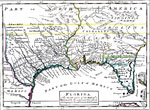
Florida : the north part of the Gulf of Mexico with the adjacent territories belonging to Great Britain and to France., 1736
Digitization provided by the USF Libraries Digitization Center. Rare Maps Collection: Notes from USF Library: Hand col. engraved map. Relief shown pictorially Scale [ca. 1:10,250,000]; (W 109000'--W 77000'/N 400--'--N 22030'). Measurements.Dimension...

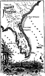
The Coast of Florida, 1736 to 1742
A map of Spanish Florida extending northward beyond the Florida peninsula into South Carolina and Port Royal. On this map the St. Johns river is labeled the River of May, with other rivers between St Augustine and Port Royal shown with French names s...

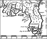
Detail of Bernard's Map Showing Florida, 1737
A portion of Bernard's map showing Florida as it was known in 1737. Digitization provided by the USF Libraries Digitization Center. Rare Maps Collection: Notes from USF Library: Relief shown pictorially. This map shows the longitude based on the Meri...


  FL Maps > State > 1720-1739
Site Map  

Maps ETC is a part of the Educational Technology Clearinghouse
Produced by the Florida Center for Instructional Technology © 2007
College of Education , University of South Florida