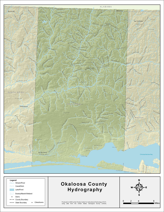
Description: This map was created by FCIT and shows the waterways of Okaloosa County. All major rivers, streams, creeks, lakes, and swamps are labeled. This map features Cobb Branch, Rock Creek, Hurricane Creek, Bull Branch, Olive Branch, Cow Pen Branch, Mare Creek, Bull Pen, Little Horse Creek, Polley Creek, Reedy Creek, Bear Branch, Big Branch, Gunn Creek, Mathison Creek, Penny Creek, Popular Head Branch, Blackwater River, Beaver Creek, Muddy Branch, Long Branch, Red Wash Branch, Pyron Spring Branch, Narrows Creek, Panther Creek, Barrel Creek, Big Creek, Billys Branch, Bay Branch, Mill Creek, Big Horse Creek, Yellow River, Murder Creek, Tyner Branch, Mack Branch, Juniper Creek, Cypress Pond Branch, Horsehead Creek, Jack Branch, Poverty Creek, Spring Branch, Pump Branch, Clear Creek, Davis Mill Creek, Bends Creek,Indian Branch, Painter Branch, Bear Creek, Shoal River, Pond Creek, Piney Woods Creek, Hannah Branch, Blackwater River, Adams Mill Creek, Bone Creek, Canoe Creek, Trawick Creek, Middle Creek, Holley Creek, Turkey Gobbler Creek, Turkey Hen Creek, Gopher Creek, Baggett Creek, Gully Branch, Trammel Creek, Shoal River, Pearl Creek, Silver Creek, Honey Creek, Titi Creek, East Dog Creek, Dog Creek, Bull Creek, Parrish Creek, Bens Creek, Turkey Creek, Rogue Creek, Anderson Branch, Swift Creek, Ninemile Creek, Bee Branch, Smith Branch, Little Rocky Creek, Middle Rocky Creek, Swift Creek, Point Lookout Creek, Long Creek, Malone Creek, Carroll Creek, Camp Creek, Yellow Creek, Metts Creek, Live Oak Creek, East Bay River, Prairie Creek, Turtle Creek, Lightwood Knot Creek, Toms Creek, Shaw Still Branch, and Rocky Creek.
Source: Florida Center for Instructional Technology, (Tampa, FL: University of South Florida, 2008)
Map Credit: Courtesy of the Florida Center for Instructional Technology |
|