Hernando
County Maps
(Benton County, 1844-1850)
Click
on a thumbnail image to view a full size version of that map.
Hernando
County is Florida's 22nd county, established on February 24, 1843,
from segments of Hillsborough County,
Mosquito County, and Alachua
County. It is one of two counties that gains its name from Hernando de
Soto, a famous Spanish explorer. From March 6, 1844, till December 24, 1850,
the county was renamed Benton in honor of Thomas Hart Benton. He gained this
honor for sponsoring the Armed Occupation Act of 1842, which was favored by
Floridians wanting to evict the Native Americans. He later fell out of favor
and the name was changed back to Hernando. Brooksville is the county seat.
For earlier
maps of this area, visit the Hillsborough
County, Mosquito County, and Alachua
County map galleries.
Record
51 to
75 of
94
|
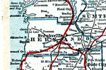
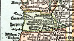
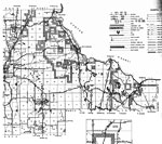
Hernando County,
1917
A map of Hernando County showing county lines, the county seat (Brooksville), railroads, canals and principal auto routes connecting the major cities current to 1917....
|
|
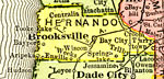
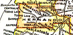
Hernando County,
1917
A map of Hernando County showing county lines, the county seat (Brooksville), railroads, and cities current to 1917....
|
|
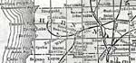
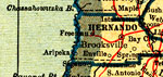
Hernando County,
1920
This detail of a map of Florida shows railroads and major cities and towns current to 1920 for Hernando County. Major waterways are present, though secondary to the railways functions. Featured cities in this detail include Brooksville, Powell, and C...
|
|
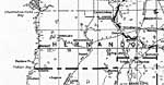
Hernando County,
1920
This map of Hernando County shows the county seat (Brooksville), railroads, and cities current to 1920....
|
|
Hernando County,
1921
A map of Hernando County showing county lines, the county seat (Brooksville), and railroads connecting the major cities current to 1921....
|
|
Hernando County,
1921
A map of Hernando County showing county lines, the county seat (Brooksville), railroads, and cities current to 1921....
|
|
Hernando County,
1932
This detail of a map of Florida shows railroads and major cities and towns current to 1932 for Hernando County. Major waterways are shown, as well as lakes, town, islands, and marsh. Other notable features are Seminole Indian Reservations, canals, an...
|

|
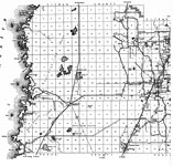
Hernando,
1936
This is a detailed map of the county of Hernando in the state of Florida. Section Township Range (STR) is shown. This map shows all of the main cities, state roads, US Highways, bridge highways, drawbridge highways, federal aided highway, saw mills, ...
|
|
East Hernando,
1936
This is a detailed map of the east portion of the county of Hernando in the state of Florida. Section Township Range (STR) is shown. This map shows all of the main cities, state roads, US Highways, bridge highways, federal aided highway, railroads, i...
|
|
West Hernando,
1936
This is a detailed map of the west portion of the county of Hernando in the state of Florida. Section Township Range (STR) is shown. This map shows all of the main cities, state roads, US Highways, bridge highways, federal aided highway, railroads, i...
|
|
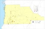
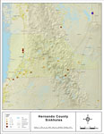
Sinkholes of Hernando County, Florida,
1948 to 2007
This map was created by FCIT and represents reported sinkhole events in Hernando County based on data gathered by the Florida Geological Survey (FGS) and the Florida Sinkhole Research Institute (FSRI) between 1948 and 2007. " This dataset repres...
|
|
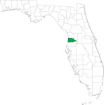
Locater Map of Hernando County,
2008
This is a locater map for Hernando County, 2008. The state is transparent while the county itself is highlighted by color. ...
|
|
Clipart Collection: Hernando County Maps in 50 Colors,
2008
A collection of simplified outline maps of Hernando County in your choice of four sizes and fifty colors. These maps are in the GIF format and have very small file sizes so they will download quickly. Use them on your Web pages or in presentations. A...
|

|
Plain Frames Collection: Hernando County Maps in 30 Colors,
2008
A collection of transparent frame maps of Hernando County in your choice of thirty colors. Combine these frames with your own photo to create a photo in the shape of the county. Use them on your Web pages or in presentations. ...
|
|
Fancy Frames Collection: Hernando County Maps in 30 styles,
2008
A collection of transparent frame maps of Hernando County in your choice of thirty styles including leaves, flowers, shells, hearts, stars, stone, and wood. Combine these frames with your own photo to create a photo in the shape of the map. Use the...
|
|
Florida Waterways: Hernando County Outline,
2008
This map was created by FCIT and shows the waterways of Hernando County. All major rivers, streams, creeks, lakes, and swamps are labeled. This map features Crawford Creek, Tooke Lake, Withlacoochee River South, Hunters Lake, and Indian Creek....
|
|
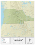
Florida Waterways: Hernando County ,
2008
This map was created by FCIT and shows the waterways of Hernando County. All major rivers, streams, creeks, lakes, and swamps are labeled. This map features Crawford Creek, Tooke Lake, Withlacoochee River South, Hunters Lake, Indian Creek, Neff Lake,...
|
|
Sinkholes of Hernando County, Florida ,
2008
This map was created by FCIT and represents reported sinkhole events in Hernando County based on data gathered by the Florida Geological Survey (FGS) and the Florida Department of Environmental Protection (FDEP). " This dataset represents a set ...
|
|
Florida Waterways: Hernando County Outline without Labels,
2008
This topographical map was created by FCIT and shows the waterways of Hernando County. All major rivers, streams, creeks, canals, bays and lakes are present, but not labeled. For a student activity sheet with directions for labeling the following: Wi...
|

|
Hernando "Abstract" Style Maps in 30 Styles,
2008
A collection of 30 Hernando County maps in a range of abstract graphic styles suitable for use in presentations and websites. Since the style is abstract, these maps can be used in projects on a wide variety of topics. Each of the maps is in the JPEG...
|
|
Hernando County "Fun" Maps in 30 Styles,
2008
A collection of 30 Hernando County maps in a crazy range of styles including blue jeans, chalkboards, pirate maps, coins, hearts, and even swimming pools. Use them as attention-getting slides in presentations or on websites. Each of the maps is in t...
|
|
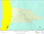
Florida Seagrass: Hernando,
2008
This topographical map was created by FCIT and shows the seagrass distribution for Hernando County. The green coloration depicts continuous seagrass while the yellow shows discontinuous seagrass. In addition to the seagrass, rivers, towns, and highw...
|

|
Hernando County Cities with Labels,
2009
This is a black and white city map of Hernando county, 2009. It shows the location with names of unincorporated cities/towns (black dot) such as Bayport, incorporated cities/towns (circle with dot) such as Weeki Wachee, and the county seat (circle wi...
|
Maps ETC
is a part of the
Educational Technology Clearinghouse
Produced by the
Florida Center for Instructional Technology
© 2007
College of Education
,
University of South Florida