Maps Site map
  FL Maps > County > Benton
Site Map  

Hernando County Maps

(Benton County, 1844-1850)

Click on a thumbnail image to view a full size version of that map.

Hernando County is Florida's 22nd county, established on February 24, 1843, from segments of Hillsborough County, Mosquito County, and Alachua County. It is one of two counties that gains its name from Hernando de Soto, a famous Spanish explorer. From March 6, 1844, till December 24, 1850, the county was renamed Benton in honor of Thomas Hart Benton. He gained this honor for sponsoring the Armed Occupation Act of 1842, which was favored by Floridians wanting to evict the Native Americans. He later fell out of favor and the name was changed back to Hernando. Brooksville is the county seat.

For earlier maps of this area, visit the Hillsborough County, Mosquito County, and Alachua County map galleries.


  Record   76   to   94  of   94

Hernando County Cities Outline, 2009
This is a black and white city outline map of Hernando county, 2009. It shows the location without names of unincorporated cities/towns (black dot), incorporated cities/towns (circle with dot), and the county seat (circle with star)....

Hernando County Road Network- Black and White, 2009
This is a black and white road map of Hernando county, 2009. It shows the location of many roads, including US-19/Commercial Way, Cortez Blvd. and Suncoast Parkway. ...

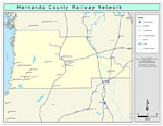
Hernando County Railway Network- Black and White, 2009
This is a black and white railroad map of Hernando county, 2009. It also shows location of cities and towns including Spring Hill and Brooksville....

Hernando County Railway Network- Color, 2009
This is a color railroad map of Hernando county, 2009. It also shows location of cities and towns including Spring Hill and Brooksville, inland water including rivers and lakes, and Amtrak stations....

Hernando County Road Network- Color, 2009
This is a color road map of Hernando county, 2009. It shows the location of many roads including US-41 and I-75, cities and towns, and inland water....

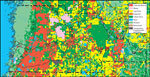
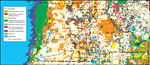
Withlacoochee River Watershed Distribution of 1995 Land Use/Cover- Hernando County, May 9, 2001
This is a county detail map of Hernando County extracted from the Southwest Florida Watershed Management District or SWFWMD Withlacoochee River Watershed Distribution of 1995 Land Use/Cover map, created on May 9, 2001. Land use/cover classifications ...

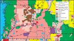
Withlacoochee River Watershed Distribution of Generalized Future Land Use, Ca. 2010- Hernando County, May 9, 2001
This is a detail map of Hernando County extracted from the Southwest Florida Watershed Management District or SWFWMD Withlacoochee River Watershed Distribution of Generalized Future Land Use, ca. 2010 map, created on May 9, 2001. Land use/cover infor...

Withlacoochee River Watershed Distribution of 1995 Agricultural Land Use/Cover- Hernando County, May 9, 2001
This is a detail map of Hernando County extracted from the Southwest Florida Watershed Management District or SWFWMD Withlacoochee River Distribution of 1995 Agricultural Land Use/Cover map, created on May 9, 2001. Agricultural land use/cover classif...

Withlacoochee River Watershed Distribution of Hazardous Waste Clean Up Sites, Landfills and Wastewater Facilities- Hernando County, May 9, 2001
This is a detail map of Hernando County extracted from the Southwest Florida Watershed Management District or SWFWMD of the Withlacoochee River Watershed Distribution of Hazardous Waste Clean Up Sites, Landfills and Wastewater Facilities map, created...

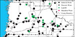
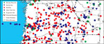
Withlacoochee River Watershed Distribution of Water Management Data Base Monitoring Sites- Hernando County, May 9, 2001
This is a detail map of Hernando County extracted from the Southwest Florida Watershed Management District or SWFWMD Withlacoochee River Watershed Distribution of Water Management Data Base Monitoring Sites map, created on May 9, 2001. This map shows...

Withlacoochee River Watershed Distribution of Soil Hydrologic Groups- Hernando County, May 9, 2001
This is a detail map of Hernando County extracted from the Southwest Florida Watershed Management District or SWFWMD Withlacoochee River Watershed Distribution of Soil Hydrologic Groups map, created on May 9, 2001. This map shows the following soil h...

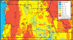
Withlacoochee River Watershed Ground Water Pollution Potential to the Floridan Aquifer (D.R.A.S.T.I.C.)- Hernando County, May 9, 2001
This is a detail map of Hernando County extracted from the Southwest Florida Watershed Management District or SWFWMD Withlacoochee River ground water pollution potential to the Floridian aquifer map, created on May 9, 2001. The pollution potential is...

Withlacoochee River Watershed Recharge to/Discharge from the Floridan Aquifer In Inches Per Year- Hernando County, May 9, 2001
This is a detail map of Hernando County extracted from the Southwest Florida Watershed Management District or SWFWMD Withlacoochee River watershed recharge to and discharge from the Floridian aquifer in inches per year map, created on May 9, 2001. Th...

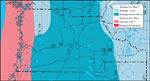
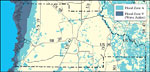
Withlacoochee River Watershed Distribution of FEMA 100-Year Flood Zones- Hernando County, May 9, 2001
This is a detail map of Hernando County from the Southwest Florida Watershed Management District or SWFWMD Withlacoochee River watershed distribution of FEMA 100-year flood zones map, created on May 9, 2001. Flood Zone A is shown in light teal and Fl...

Withlacoochee River Watershed Distribution of 1995 Urban Land Use Within the FEMA 100-Year Flood Zone- Hernando County, May 9, 2001
This is a detail map of Hernando County extracted from the Southwest Florida Watershed Management District or SWFWMD Withlacoochee River watershed distribution of 1995 urban land use within the FEMA 100-year flood zone map, created on May 9, 2001. Th...

Withlacoochee River Watershed Distribution of Natural Systems - 1995- Hernando County, May 9, 2001
This is a detail map of Hernando County extracted from the Southwest Florida Watershed Management District or SWFWMD Withlacoochee River watershed distribution of natural systems- 1995 map, created on May 9, 2001. The following natural system classif...

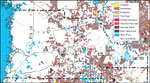
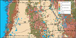
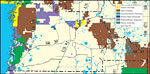
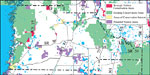
Withlacoochee River Watershed Distribution of Conservation Lands- Hernando County, May 9, 2001
This is a detail map of Hernando County extracted from the Southwest Florida Watershed Management District or SWFWMD Withlacoochee River watershed distribution of conservation lands map, created on May 9, 2001. The following ownership classifications...

Withlacoochee River Watershed Strategic Habitat Conservation Areas, Areas of Conservation Interest, and Potential Natural Areas- Hernando County, May 9, 2001
This is a detail map of Hernando County extracted from the Southwest Florida Watershed Management District or SWFWMD Withlacoochee River watershed strategic habitat conservation area, areas of conservation interest and potential natural areas map, cr...

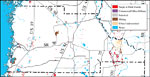
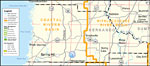
Southwest Florida Water Management District- Hernando County, September 28, 2004
This is a county detail map of Hernando County extracted from the Southwest Florida Watershed Management District or SWFWMD district map, created on September 28, 2004. This map shows major inland water, township/range lines (in pink), county boundar...

First Previous


  FL Maps > County > Benton
Site Map  

Maps ETC is a part of the Educational Technology Clearinghouse
Produced by the Florida Center for Instructional Technology © 2007
College of Education , University of South Florida