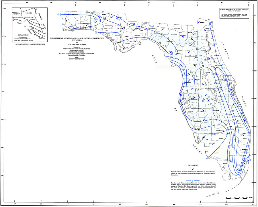
Description: This is a map of Florida showing the difference between rainfall and potential evaporation, current to 1975. The following is taken from the article "The Difference Between Rainfall and Potential Evaporation in Florida" by F. N. Visher and G. H. Hughes — "Rainfall in Florida is generally abundant, but man presently has little opportunity to control or direct the use of a large part of the total rainfall." As shown in the key, the blue dots represent rainfall stations and the number represents the difference in inches between rainfall at the station and the potential evaporation in the general area of the station. The blue lines mark approximate boundaries of areas where the difference between rainfall and potential evaporation is generally the same within a range of 3 inches. Please see the article The Difference Between Rainfall and Potential Evaporation in Florida by F. N. Visher and G. H. Hughes for more information.
Place Names: 1950-1999, Counties, Hillsborough, Atlantic Ocean, Gulf of Mexico, Lake Okeechobee, Orange, St. Johns River, Suwannee River
ISO Topic Categories: boundaries, inlandWaters, oceans, environment, climatologyMeteorologyAtmosphere
Keywords: Difference Between Rainfall and Potential Evaporation, hydrological, physical, meteorological, rainfall, evaporation, rainfall, boundaries, inlandWaters, oceans, environment, climatologyMeteorologyAtmosphere, Unknown,1975
Source: U. S. Geological Survey, Bureau of Geology, Florida Department of Natural Resources , Florida Water Atlas (Tallahassee, FL: Bureau of Geology, 1976)
Map Credit: Courtesy the University of South Florida Library |
|