Maps Site map
  FL Maps > Region > 2000-
Site Map  

  Record   101   to   125  of   217

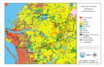
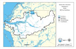
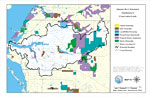
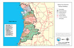
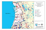
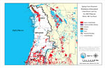
Manatee River Watershed Distribution of 1995 Land Use/Cover- Map 2, December 5, 2000
This is a map from the Southwest Florida Watershed Management District or SWFWMD of the Manatee River watershed distribution of 1995 land use/cover created on December 5, 2000. This map shows the Watershed Management boundary shown by the thick black...

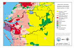
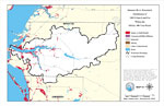
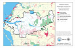
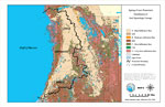
Manatee River Watershed Distribution of Generalized Future Land Use, Ca. 2010- Map 3, December 5, 2000
This is a map from the Southwest Florida Watershed Management District or SWFWMD of the Manatee River watershed distribution of generalized future land use, ca. 2010 created on December 5, 2000. This map shows the Watershed Management boundary shown ...

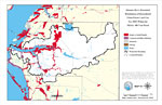
Manatee River Watershed Distribution of Superfund Sites, Landfills and Wastewater Facilities- Map 6, December 5, 2000
This is a map from the Southwest Florida Watershed Management District or SWFWMD of the Manatee River watershed distribution of superfund sites, landfills and wastewater facilities created on December 5, 2000. This map shows industrial waste (black d...

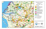
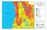
Manatee River Watershed Recharge to/Discharge from the Floridan Aquifer in Inches Per Year- Map 10, December 5, 2000
This is a map from the Southwest Florida Watershed Management District or SWFWMD of the Manatee River watershed recharge to and discharge from the Floridian aquifer in inches per year created on December 5, 2000. The recharge and discharge are shown ...

Manatee River Watershed Distribution of FEMA 100-Year Flood Zones- Map 11, December 5, 2000
This is a map from the Southwest Florida Watershed Management District or SWFWMD of the Manatee River watershed distribution of FEMA 100-year flood zones created on December 5, 2000. Flood Zone A is shown in light blue and Flood Zone V (wave action) ...

Manatee River Watershed Distribution of 1995 Urban Land Use Within the FEMA 100-Year Flood Zone- Map 12, December 5, 2000
This is a map from the Southwest Florida Watershed Management District or SWFWMD of the Manatee River watershed distribution of 1995 urban land use within the FEMA 100-year flood zone created on December 5, 2000. The following urban land use classifi...

Manatee River Watershed Distribution of Generalized Urban Future Land Use, Ca. 2010 Within the FEMA 100-Year Flood Zone- Map 13, December 5, 2000
This is a map from the Southwest Florida Watershed Management District or SWFWMD of the Manatee River watershed distribution generalized urban future land use circa 2010 within the FEMA 100-year flood zone created on December 5, 2000. The following u...

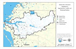
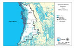
Manatee River Watershed Distribution of Natural Systems - 1990- Map 14, December 5, 2000
This is a map from the Southwest Florida Watershed Management District or SWFWMD of the Manatee River watershed distribution of natural systems from 1995, created on December 5, 2000. The following natural system classifications are shown by color: r...

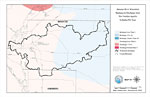
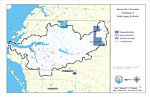
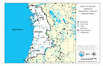
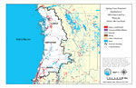
Manatee River Watershed Distribution of Conservation Lands- Map 15, December 5, 2000
This is a map from the Southwest Florida Watershed Management District or SWFWMD of the Manatee River watershed distribution of conservation lands, created on December 5, 2000. The following ownership classifications are shown by color: Federal Owner...

Manatee River Watershed Strategic Habitat Conservation Areas, Areas of Conservation Interest, and Potential Natural Areas- Map 16, December 5, 2000
This is a map from the Southwest Florida Watershed Management District or SWFWMD of the Manatee River watershed strategic habitat conservation area, areas of conservation interest and potential natural areas, created on December 5, 2000. The followin...

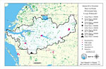
Manatee River Watershed Distribution of Public Supply Wellfields- Map 17, December 5, 2000
This is a map from the Southwest Florida Watershed Management District or SWFWMD of the Manatee River watershed distribution of public supply wellfields, created on December 5, 2000. This map shows permitted wellfields (dark blue) and proposed wells ...

Manatee River Watershed Water Use Permits 1995 Estimated Daily Average Withdrawals- Map 18, December 5, 2000
This is a map from the Southwest Florida Watershed Management District or SWFWMD of the Manatee River watershed water use permits 1995 estimated daily average withdrawals, created on December 5, 2000. The following pumpage values are shown with black...

Manatee River Watershed Historic Vegetation- Map 19, December 6, 2000
This is a map from the Southwest Florida Watershed Management District or SWFWMD of the Manatee River watershed historic vegetation, created on December 6, 2000. The following historic vegetation classifications are shown by color: Pine Flatwoods (li...

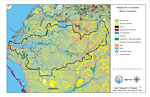
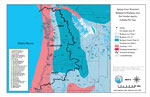
Springs Coast Watershed General Location Information, February 23, 2001
This is a map from the Southwest Florida Watershed Management District or SWFWMD of the Springs Coast watershed general location information, created on February 23, 2001. This map shows the Watershed Management boundary shown by the thick black line...

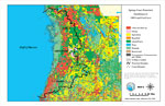
Springs Coast Watershed Distribution of 1995 Land Use/Cover, February 23, 2001
This is a map from the Southwest Florida Watershed Management District or SWFWMD of the Springs Coast watershed distribution of 1995 land use/cover, created on February 23, 2001. The watershed boundary is shown by a thick black line. Land use/cover c...

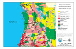
Springs Coast Watershed Distribution of Generalized Future Land Use, Ca. 2010, February 23, 2001
This is a map from the Southwest Florida Watershed Management District or SWFWMD of the Springs Coast watershed distribution of generalized future land use, ca. 2010, created on February 23, 2001. This map shows the Watershed Management boundary show...

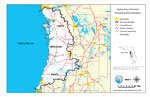
Springs Coast Watershed Drainage Sub Basins, February 23, 2001
This is a map from the Southwest Florida Watershed Management District or SWFWMD of the Springs Coast watershed drainage sub basins, created on February 23, 2001. Each sub basin is numbered shown to the left of the map. The sub basins are also separa...

Springs Coast Watershed Recharge to/Discharge from the Floridan Aquifer in Inches Per Year, February 23, 2001
This is a map from the Southwest Florida Watershed Management District or SWFWMD of the Springs Coast watershed recharge to and discharge from the Floridian aquifer in inches per year, created on February 23, 2001. The recharge and discharge are show...

Springs Coast Watershed Ground Water Pollution Potential to the Floridan Aquifer (D.R.A.S.T.I.C.), February 23, 2001
This is a map from the Southwest Florida Watershed Management District or SWFWMD of the Springs Coast ground water pollution potential to the Floridian aquifer, created on February 23, 2001. The pollution potential is shown with a composite DRASTIC s...

Springs Coast Watershed Distribution of Superfund Sites, Landfills and Wastewater Facilities, February 23, 2001
This is a map from the Southwest Florida Watershed Management District or SWFWMD of the Springs Coast watershed distribution of superfund sites, landfills and wastewater facilities, created on February 23, 2001. This map shows industrial waste (black...

Springs Coast Watershed Distribution of Water Management Data Base Monitoring Sites, February 23, 2001
This is a map from the Southwest Florida Watershed Management District or SWFWMD of the Springs Coast watershed distribution of water management data base monitoring sites, created on February 23, 2001. This map shows Stream Flow (green circle with d...

Springs Coast Watershed Distribution of Soil Hydrologic Groups, February 23, 2001
This is a map from the Southwest Florida Watershed Management District or SWFWMD of the Springs Coast watershed distribution of soil hydrologic groups, created on February 23, 2001. This map shows the following soil hydrologic groups: A- high infiltr...

Springs Coast Watershed Distribution of FEMA 100-Year Flood Zones, February 23, 2001
This is a map from the Southwest Florida Watershed Management District or SWFWMD of the Springs Coast watershed distribution of FEMA 100-year flood zones, created on February 23, 2001. Flood Zone A is shown in light teal and Flood Zone V (wave action...

Springs Coast Watershed Distribution of 1995 Urban Land Use Within the FEMA 100-Year Flood, February 23, 2001
This is a map from the Southwest Florida Watershed Management District or SWFWMD of the Springs Coast watershed distribution of 1995 urban land use within the FEMA 100-year flood zone, created on February 23, 2001. The following urban land use classi...

Springs Coast Watershed Distribution of Generalized Urban Future Land Use, Ca. 2010 Within the FEMA 100-Year Flood, February 23, 2001
This is a map from the Southwest Florida Watershed Management District or SWFWMD of the Springs Coast watershed distribution generalized urban future land use circa 2010 within the FEMA 100-year flood zone, created on February 23, 2001. The following...

First Previous Next Last


  FL Maps > Region > 2000-
Site Map  

Maps ETC is a part of the Educational Technology Clearinghouse
Produced by the Florida Center for Instructional Technology © 2007
College of Education , University of South Florida