Maps Site map
  FL Maps > Region > 2000-
Site Map  

  Record   76   to   100  of   217

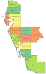
Florida's Southwest Counties, 2007
This is a color outline map of Florida's southwest counties. Counties are labeled with their names....

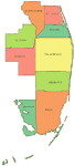
Florida's Southeast Counties, 2007
This is a color outline map of Florida's southeast counties. Counties are labeled with their names....

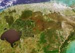
3 Dimensional Image of Florida, April 9, 2000
Multi-angle Imaging SpectroRadiometer (MISR) images of Florida acquired on April 9, 2000 during Terra orbit 1650. The image at the top is a color view acquired by the vertical (nadir) camera. It has been reoriented so that the flight path is from lef...

3 Dimensional Image of Florida- Detail of East Central Florida, April 9, 2000
Multi-angle Imaging SpectroRadiometer (MISR) images of Florida acquired on April 9, 2000 during Terra orbit 1650. This is a detail of east central Florida. The image at the top is a color view acquired by the vertical (nadir) camera. It has been reor...

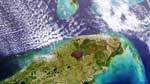
3 Dimensional Image of Florida- Detail of South Florida, April 9, 2000
Multi-angle Imaging SpectroRadiometer (MISR) images of Florida acquired on April 9, 2000 during Terra orbit 1650. This is a detail of South Florida. The image at the top is a color view acquired by the vertical (nadir) camera. It has been reoriented ...

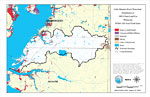
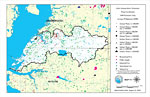
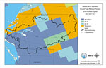
Little Manatee River Watershed Distribution of 1995 Urban Land Use Within the FEMA 100-Year Flood Zone- Map 9, August 1, 2001
This is a map from the Southwest Florida Watershed Management District or SWFWMD of the Little Manatee River watershed distribution of 1995 urban land use within the FEMA 100-year flood zone created on August 1, 2001. The following urban land use cla...

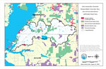
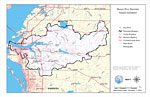
Little Manatee River Watershed Strategic Habitat Conservation Areas, Areas of Conservation Interest, and Potential Natural Areas- Map 12, August 1, 2001
This is a map from the Southwest Florida Watershed Management District or SWFWMD of the Little Manatee River watershed strategic habitat conservation area, areas of conservation interest and potential natural areas, created on August 1, 2001. The fol...

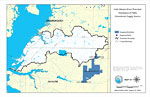
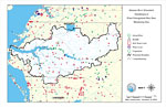
Little Manatee River Watershed Distribution of Public Groundwater Supply Sources- Map 13, August 1, 2001
This is a map from the Southwest Florida Watershed Management District or SWFWMD of the Little Manatee River watershed distribution of public groundwater supply sources, created on August 1, 2001. This map shows permitted wellfields (dark blue) and d...

Little Manatee River Watershed Water Use Permits 1998 Estimated Daily Average Withdrawals (GPD)- Map 14, August 1, 2001
This is a map from the Southwest Florida Watershed Management District or SWFWMD of the Little Manatee River watershed water use permits 1998 estimated daily average withdrawals (GPD), created on August 1, 2001. The following pumpage values are shown...

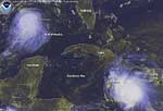
Tropical Storms Bonnie and Charley, August 11, 2004
This is a satellite image showing tropical storms Bonnie and Charley in the Gulf of Mexico and the Caribbean Sea on August 11, 2004 at 10:45 AM....

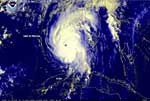
Hurricane Charley Approaching Florida, August 13, 2004
This is a satellite image showing Hurricane Charley approaching the Florida coast on August 13, 2004 9:45 AM with winds near 110 mph and higher gusts. ...

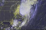
Hurricane Charley Making Landfall Again, August 14, 2004
This is a satellite image showing Hurricane Charley making landfall again near Georgetown, South Carolina on August 14, 2004 at 10:15 PM....

Little Manatee River Watershed Distribution of 1995 Agricultural Land Use/Cover- Map 4, August 2, 2001
This is a map from the Southwest Florida Watershed Management District or SWFWMD of the Little Manatee River watershed distribution of 1995 agricultural land use/cover created on August 2, 2001. This map shows the Watershed Management boundary shown ...

Little Manatee River Watershed Distribution of Hazardous Waste Clean Up Sites, Landfills and Wastewater Facilities- Map 5, August 2, 2001
This is a map from the Southwest Florida Watershed Management District or SWFWMD of the Little Manatee River watershed distribution of hazardous waste clean up sites, landfills and wastewater facilities created on August 2, 2001. This map shows indus...

Little Manatee River Watershed Distribution of Water Management Data Base Monitoring Sites- Map 6, August 2, 2001
This is a map from the Southwest Florida Watershed Management District or SWFWMD of the Little Manatee River watershed distribution of water management data base monitoring sites created on August 2, 2001. This map shows flowing water sites with a gr...

Little Manatee River Watershed Distribution of Soil Hydrologic Groups- Map 7, August 2, 2001
This is a map from the Southwest Florida Watershed Management District or SWFWMD of the Little Manatee River watershed distribution of soil hydrologic groups created on August 2, 2001. This map shows the following soil hydrologic groups: A- high infi...

Little Manatee River Watershed Distribution of FEMA 100-Year Flood Zones- Map 8, August 2, 2001
This is a map from the Southwest Florida Watershed Management District or SWFWMD of the Little Manatee River watershed distribution of FEMA 100-year flood zones created on August 2, 2001. Flood Zone A is shown in light teal and Flood Zone V (wave act...

Little Manatee River Watershed Distribution of Natural Systems - 1995- Map 10, August 2, 2001
This is a map from the Southwest Florida Watershed Management District or SWFWMD of the Little Manatee River watershed distribution of natural systems from 1995, created on August 2, 2001. The following natural system classifications are shown by col...

Little Manatee River Watershed Distribution of Conservation Lands- Map 11, August 2, 2001
This is a map from the Southwest Florida Watershed Management District or SWFWMD of the Little Manatee River watershed distribution of conservation lands, created on August 2, 2001. The following ownership classifications are shown by color: Federal ...

Manatee River Watershed Distribution of 1995 Agricultural Land Use/Cover- Map 4, December 11, 2000
This is a map from the Southwest Florida Watershed Management District or SWFWMD of the Manatee River watershed distribution of 1995 agricultural land use/cover created on December 11, 2000. This map shows the Watershed Management boundary shown by t...

Manatee River Watershed Drainage Sub Basins- Map 5, December 11, 2000
This is a map from the Southwest Florida Watershed Management District or SWFWMD of the Manatee River watershed drainage sub-basins created on December 11, 2001. Each sub basin is shown with the names and separated by colors. This map shows the Water...

Manatee River Watershed Distribution of Soil Hydrologic Groups- Map 8, December 11, 2000
This is a map from the Southwest Florida Watershed Management District or SWFWMD of the Manatee River watershed distribution of soil hydrologic groups created on December 11, 2000. This map shows the following soil hydrologic groups: A- high infiltra...

Manatee River Watershed Ground Water Pollution Potential to the Floridan Aquifer (D.R.A.S.T.I.C.)- Map 9, December 11, 2000
This is a map from the Southwest Florida Watershed Management District or SWFWMD of the Manatee River ground water pollution potential to the Floridian aquifer created on December 11, 2000. The pollution potential is shown with a composite DRASTIC sc...

Manatee River Watershed General Information- Map 1, December 11, 2001
This is a map from the Southwest Florida Watershed Management District or SWFWMD of the Manatee River watershed general location information created on December 11, 2001. This map shows the Watershed Management boundary shown by the thick black line,...

Manatee River Watershed Distribution of Water Management Data Base Monitoring Sites- Map 7, December 19, 2000
This is a map from the Southwest Florida Watershed Management District or SWFWMD of the Manatee River watershed distribution of water management data base monitoring sites created on December 19, 2000. This map shows stream flow sites (green circle),...

First Previous Next Last


  FL Maps > Region > 2000-
Site Map  

Maps ETC is a part of the Educational Technology Clearinghouse
Produced by the Florida Center for Instructional Technology © 2007
College of Education , University of South Florida