Maps Site map
  FL Maps > Region > 2000-
Site Map  

  Record   201   to   217  of   217

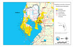
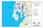
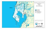
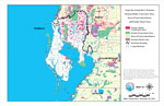
Tampa Bay/Anclote River Watershed General Location Information, November 30, 2001
This is a map from the Southwest Florida Watershed Management District or SWFWMD of the Tampa Bay/Anclote River watershed general location information, created on November 30, 2001. This map shows the Watershed Management boundary shown by the thick ...

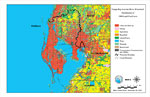
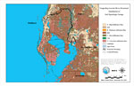
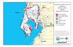
Tampa Bay/Anclote River Watershed Distribution of 1999 Land Use/Cover, November 30, 2001
This is a map from the Southwest Florida Watershed Management District or SWFWMD of the Tampa Bay/Anclote River watershed distribution of 1999 land use/cover, created on November 30, 2001. The watershed boundary is shown by a thick black line. Land u...

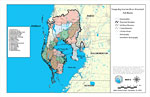
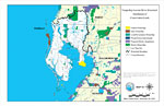
Tampa Bay/Anclote River Watershed Sub-Basins, November 30, 2001
This is a map from the Southwest Florida Watershed Management District or SWFWMD of the Tampa Bay/Anclote River watershed sub basins, created on November 30, 2001. Each sub basin is numbered shown to the left of the map. The sub basins are also separ...

Tampa Bay/Anclote River Watershed Distribution of Hazardous Waste Clean Up Sites, Landfills and Wastewater Facilities, November 30, 2001
This is a map from the Southwest Florida Watershed Management District or SWFWMD of the Tampa Bay/Anclote River watershed distribution of hazardous waste clean up sites, landfills and wastewater facilities, created on November 30, 2001. This map show...

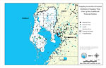
Tampa Bay/Anclote River Watershed Distribution of Water Management Data Base Monitoring Sites, November 30, 2001
This is a map from the Southwest Florida Watershed Management District or SWFWMD of the Tampa Bay/Anclote River watershed distribution of water management data base monitoring sites, created on November 30, 2001. This map shows the following monitori...

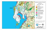
Tampa Bay/Anclote River Watershed Distribution of Soil Hydrologic Groups, November 30, 2001
This is a map from the Southwest Florida Watershed Management District or SWFWMD of the Tampa Bay/Anclote River watershed distribution of soil hydrologic groups, created on November 30, 2001. This map shows the following soil hydrologic groups: A- hi...

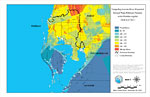
Tampa Bay/Anclote River Watershed Ground Water Pollution Potential to the Floridan Aquifer (D.R.A.S.T.I.C.), November 30, 2001
This is a map from the Southwest Florida Watershed Management District or SWFWMD of the Tampa Bay/Anclote River ground water pollution potential to the Floridian aquifer, created on November 30, 2001. The pollution potential is shown with a composite...

Tampa Bay/Anclote River Watershed Recharge to/Discharge from the Floridan Aquifer in Inches Per Year, November 30, 2001
This is a map from the Southwest Florida Watershed Management District or SWFWMD of the Tampa Bay/Anclote River watershed recharge to and discharge from the Floridian aquifer in inches per year, created on November 30, 2001. The recharge and discharg...

Tampa Bay/Anclote River Watershed Distribution of FEMA 100-Year Flood Zones, November 30, 2001
This is a map from the Southwest Florida Watershed Management District or SWFWMD of the Tampa Bay/Anclote River watershed distribution of FEMA 100-year flood zones, created on November, 2001. Flood Zone A is shown in teal and Flood Zone V (wave actio...

Tampa Bay/Anclote River Watershed Distribution of 1999 Urban Land Use Within the FEMA 100-Year Flood Zone, November 30, 2001
This is a map from the Southwest Florida Watershed Management District or SWFWMD of the Tampa Bay/Anclote River watershed distribution of 1999 urban land use within the FEMA 100-year flood zone, created on November 30, 2001. The following urban land ...

Tampa Bay/Anclote River Watershed Distribution of Natural Systems - 1999, November 30, 2001
This is a map from the Southwest Florida Watershed Management District or SWFWMD of the Tampa Bay/Anclote River watershed distribution of natural systems from 1999, created on November 30, 2001. The following natural system classifications are shown ...

Tampa Bay/Anclote River Watershed Distribution of Conservation Lands, November 30, 2001
This is a map from the Southwest Florida Watershed Management District or SWFWMD of the Tampa Bay/Anclote River watershed distribution of conservation lands, created on November 30, 2001. The following ownership classifications are shown by color: Fe...

Tampa Bay/Anclote River Watershed Strategic Habitat Conservation Areas, Areas of Conservation Interest, and Potential Natural Areas, November 30, 2001
This is a map from the Southwest Florida Watershed Management District or SWFWMD of the Tampa Bay/Anclote River watershed strategic habitat conservation area, areas of conservation interest and potential natural areas, created on November 30, 2001. T...

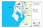
Tampa Bay/Anclote River Watershed Distribution of Public Groundwater Supply Sources, November 30, 2001
This is a map from the Southwest Florida Watershed Management District or SWFWMD of the Tampa Bay/Anclote River watershed distribution of public groundwater supply sources, created on November 30, 2001. This map shows permitted wellfields (dark blue)...

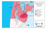
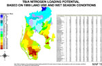
Tampa Bay/Anclote River Watershed Nitrogen Loading Potential Based on 1999 Land Use and Wet Season Conditions, November 30, 2001
This is a map from the Southwest Florida Watershed Management District or SWFWMD of the Tampa Bay/Anclote River watershed nitrogen loading potential based on 1999 land use and wet conditions, created in 2001. This map shows the loading potential by c...

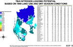
Tampa Bay/Anclote River Watershed Nitrogen Loading Potential Based on 1999 Land Use and Dry Season Conditions, November 30, 2001
This is a map from the Southwest Florida Watershed Management District or SWFWMD of the Tampa Bay/Anclote River watershed nitrogen loading potential based on 1999 land use and dry conditions, created in 2001. This map shows the loading potential by c...

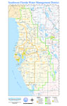
Southwest Florida Water Management District, September 28, 2004
This is a map from the Southwest Florida Watershed Management District or SWFWMD of the their water management districts, created on September 28, 2004. This map shows the districts outlined in bright green. It also shows major inland water, oceans, ...

First Previous


  FL Maps > Region > 2000-
Site Map  

Maps ETC is a part of the Educational Technology Clearinghouse
Produced by the Florida Center for Instructional Technology © 2007
College of Education , University of South Florida