Maps Site map
  FL Maps > Region > 2000-
Site Map  

  Record   176   to   200  of   217

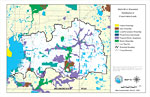
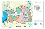
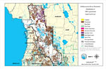
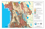
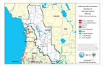
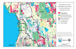
Alafia River Watershed Distribution of Conservation Lands- Map 15, May 7, 2001
This is a map from the Southwest Florida Watershed Management District or SWFWMD of the Alafia River watershed distribution of conservation lands, created on May 7, 2001. The following ownership classifications are shown by color: Federal Ownership (...

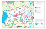
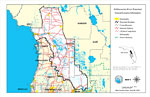
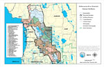
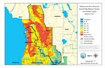
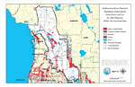
Alafia River Watershed Strategic Habitat Conservation Areas, Areas of Conservation Interest, and Potential Natural Areas- Map 16, May 7, 2001
This is a map from the Southwest Florida Watershed Management District or SWFWMD of the Alafia River watershed strategic habitat conservation area, areas of conservation interest and potential natural areas, created on May 7, 2001. The following clas...

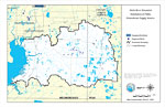
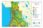
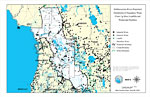
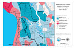
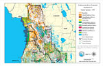
Alafia River Watershed Distribution of Public Groundwater Supply Sources- Map 17, May 7, 2001
This is a map from the Southwest Florida Watershed Management District or SWFWMD of the Alafia River watershed distribution of public groundwater supply sources, created on May 7, 2001. This map shows permitted wellfields (dark blue) and dispersed we...

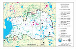
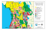
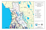
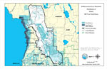
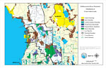
Alafia River Watershed Water Use Permits 1998 Estimated Daily Average Withdrawals (GPD)- Map 18, May 7, 2001
This is a map from the Southwest Florida Watershed Management District or SWFWMD of the Alafia River watershed water use permits 1998 estimated daily average withdrawals (GPD), created on May 7, 2001. The following pumpage values are shown with black...

Alafia River Watershed Drainage Sub-Basins- Map 5, May 8, 2001
This is a map from the Southwest Florida Watershed Management District or SWFWMD of the Alafia River watershed drainage sub-basins created on May 8, 2001. Each sub basin is shown with the names and separated by colors. This map shows the Watershed Ma...

Withlacoochee River Watershed, May 9, 2001
This is a map from the Southwest Florida Watershed Management District or SWFWMD of the Withlacoochee River Watershed general location information, created on May 9, 2001. This map shows the Watershed Management boundary shown by the thick black line...

Withlacoochee River Watershed Distribution of 1995 Land Use/Cover, May 9, 2001
This is a map from the Southwest Florida Watershed Management District or SWFWMD of the Withlacoochee River watershed distribution of 1995 land use/cover, created on May 9, 2001. The watershed boundary is shown by a thick black line. Land use/cover c...

Withlacoochee River Watershed Distribution of Generalized Future Land Use, Ca. 2010, May 9, 2001
This is a map from the Southwest Florida Watershed Management District or SWFWMD of the Withlacoochee River watershed distribution of generalized future land use, ca. 2010, created on May 9, 2001. This map shows the Watershed Management boundary show...

Withlacoochee River Watershed Distribution of 1995 Agricultural Land Use/Cover, May 9, 2001
This is a map from the Southwest Florida Watershed Management District or SWFWMD of the Withlacoochee River watershed distribution of 1995 agricultural land use/cover, created on May 9, 2001. This map shows the Watershed Management boundary shown by ...

Withlacoochee River Watershed Drainage Sub-Basins, May 9, 2001
This is a map from the Southwest Florida Watershed Management District or SWFWMD of the Withlacoochee River watershed drainage sub-basins, created on May 9, 2001. Each sub basin is shown with the names and separated by colors. This map shows the Wate...

Withlacoochee River Watershed Distribution of Hazardous Waste Clean Up Sites, Landfills and Wastewater Facilities, May 9, 2001
This is a map from the Southwest Florida Watershed Management District or SWFWMD of the Withlacoochee River watershed distribution of hazardous waste clean up sites, landfills and wastewater facilities created on May 9, 2001. This map shows industria...

Withlacoochee River Watershed Distribution of Water Management Data Base Monitoring Sites, May 9, 2001
This is a map from the Southwest Florida Watershed Management District or SWFWMD of the Withlacoochee River watershed distribution of water management data base monitoring sites, created on May 9, 2001. This map shows flowing water sites with a green...

Withlacoochee River Watershed Distribution of Soil Hydrologic Groups, May 9, 2001
This is a map from the Southwest Florida Watershed Management District or SWFWMD of the Withlacoochee River watershed distribution of soil hydrologic groups, created on May 9, 2001. This map shows the following soil hydrologic groups: A- high infiltr...

Withlacoochee River Watershed Ground Water Pollution Potential to the Floridan Aquifer (D.R.A.S.T.I.C.), May 9, 2001
This is a map from the Southwest Florida Watershed Management District or SWFWMD of the Withlacoochee River ground water pollution potential to the Floridian aquifer created on May 9, 2001. The pollution potential is shown with a composite DRASTIC sc...

Withlacoochee River Watershed Recharge to/Discharge from the Floridan Aquifer In Inches Per Year, May 9, 2001
This is a map from the Southwest Florida Watershed Management District or SWFWMD of the Withlacoochee River watershed recharge to and discharge from the Floridian aquifer in inches per year, created on May 9, 2001. The recharge and discharge are show...

Withlacoochee River Watershed Distribution of FEMA 100-Year Flood Zones, May 9, 2001
This is a map from the Southwest Florida Watershed Management District or SWFWMD of the Withlacoochee River watershed distribution of FEMA 100-year flood zones created on May 9, 2001. Flood Zone A is shown in light teal and Flood Zone V (wave action)...

Withlacoochee River Watershed Distribution of 1995 Urban Land Use Within the FEMA 100-Year Flood Zone, May 9, 2001
This is a map from the Southwest Florida Watershed Management District or SWFWMD of the Withlacoochee River watershed distribution of 1995 urban land use within the FEMA 100-year flood zone, created on May 9, 2001. The following urban land use classi...

Withlacoochee River Watershed Distribution of Generalized Urban Future Land Use, Ca. 2010 Within the FEMA 100-Year Flood Zone, May 9, 2001
This is a map from the Southwest Florida Watershed Management District or SWFWMD of the Withlacoochee River watershed distribution generalized urban future land use circa 2010 within the FEMA 100-year flood zone, created on May 9, 2001. The following...

Withlacoochee River Watershed Distribution of Natural Systems - 1995, May 9, 2001
This is a map from the Southwest Florida Watershed Management District or SWFWMD of the Withlacoochee River watershed distribution of natural systems from 1995, created on May 9, 2001. The following natural system classifications are shown by color: ...

Withlacoochee River Watershed Distribution of Conservation Lands, May 9, 2001
This is a map from the Southwest Florida Watershed Management District or SWFWMD of the Withlacoochee River watershed distribution of conservation lands, created on May 9, 2001. The following ownership classifications are shown by color: Federal Owne...

Withlacoochee River Watershed Strategic Habitat Conservation Areas, Areas of Conservation Interest, and Potential Natural Areas, May 9, 2001
This is a map from the Southwest Florida Watershed Management District or SWFWMD of the Withlacoochee River watershed strategic habitat conservation area, areas of conservation interest and potential natural areas, created on May 9, 2001. The followi...

Withlacoochee River Watershed Distribution of Public Groundwater Supply Source, May 9, 2001
This is a map from the Southwest Florida Watershed Management District or SWFWMD of the Withlacoochee River watershed distribution of public groundwater supply sources, created on May 9, 2001. This map shows permitted wellfields (dark blue) and dispe...

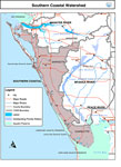
Southern Coastal Watershed, n. d.
This is a map from the Southwest Florida Watershed Management District or SWFWMD of the Southern Coastal watershed. This map shows the Comprehensive Watershed Management or CWM boundary (thick gray line), outstanding Florida waters highlighted in lav...

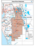
Peace River Watershed, n. d.
This is a map from the Southwest Florida Watershed Management District or SWFWMD of the Peace River watershed. This map shows the Comprehensive Watershed Management or CWM boundary (thick gray line), surrounding cities, major roads, rivers and lakes ...

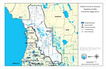
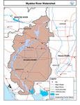
Myakka River Watershed, n. d.
This is a map from the Southwest Florida Watershed Management District or SWFWMD of the Myakka River watershed. This map shows the Comprehensive Watershed Management or CWM boundary (thick gray line), Outstanding Florida Waters (lavender), surroundin...

First Previous Next Last


  FL Maps > Region > 2000-
Site Map  

Maps ETC is a part of the Educational Technology Clearinghouse
Produced by the Florida Center for Instructional Technology © 2007
College of Education , University of South Florida