Maps Site map
  FL Maps > Region > 1950-1999
Site Map  

  Record   126   to   150  of   261

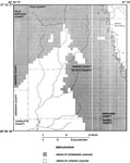
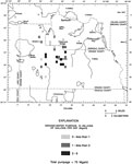
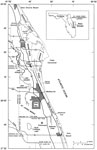
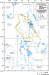
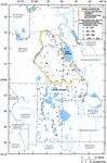
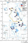
Areas of Leakage through the Lower Confining Unit in Hardee and De Soto Counties, 1988
This map from the U. S. Geological Survey Water Resources Investigation Report number 93-4158, Hydrology and Simulated Effects of Groundwater Withdrawals for Citrus Irrigation, Hardee and De Soto Counties, shows the areas in Hardee and De Soto counti...

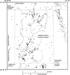
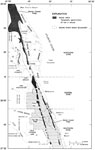
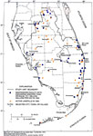
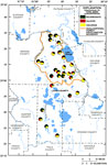
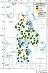
Locations of Citrus Irrigation Wells Open to the Intermediate Aquifer System, 1988
This map from the U. S. Geological Survey Water Resources Investigation Report number 93-4158, Hydrology and Simulated Effects of Groundwater Withdrawals for Citrus Irrigation, Hardee and De Soto Counties, shows the location of citrus irrigation well...

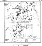
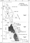
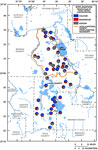
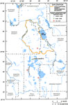
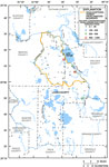
Locations of Citrus Irrigation Wells Open to the Upper Floridan Aquifer System, 1988
This map from the U. S. Geological Survey Water Resources Investigation Report number 93-4158, Hydrology and Simulated Effects of Groundwater Withdrawals for Citrus Irrigation, Hardee and De Soto Counties, shows the location of citrus irrigation well...

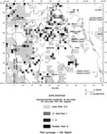
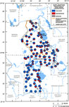
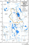
Distribution of Average Pumpage of the Upper Floridan Aquifer in the Greater Orlando Metropolitan Area, 1988
This map from the U. S. Geological Survey Water Resources Investigation Report number 96-4181, Hydrogeologic Conditions and Simulation of Ground Water Flow in the Greater Orlando Metropolitan Area, shows the generalized distribution of average 1988 U...

Distribution of Average Pumpage of the Lower Floridan Aquifer in the Greater Orlando Metropolitan Area, 1988
This map from the U. S. Geological Survey Water Resources Investigation Report number 96-4181, Hydrogeologic Conditions and Simulation of Ground Water Flow in the Greater Orlando Metropolitan Area, shows the generalized distribution of average 1988 L...

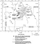
Simulated Groundwater Flow in the Greater Orlando Metropolitan Area, 1988
This map from the U. S. Geological Survey Water Resources Investigation Report number 96-4181, Hydrogeologic Conditions and Simulation of Ground Water Flow in the Greater Orlando Metropolitan Area, shows simulated pathlines of groundwater flow in the...

The Charlotte Harbor Estuarine System, 1988
This map from the U. S. Geological Survey Open-File Report Report number 87-472 shows the Charlotte Harbor estuarine system, including discharge points of the Myakka, Peace, and Caloosahatchee rivers....

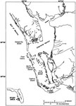
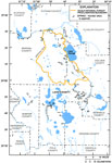
Charlotte Harbor Inflow Area, 1988
This map from the U. S. Geological Survey Open-File Report Report number 87-472 shows the drainage basins that discharge into the Charlotte Harbor estuarine system. These drainage basins include the Peace, Myakka, Caloosahatchee river basins and the ...

Location of the Indian River Basin within the St. Johns River Water Management District, 1989 to 1991
This map from the U. S. Geological Survey Water Resources Investigation Report number 97-4011, Rainfall and Freshwater Discharge in the Indian River Basin, shows the location of the study basin, including major municipalities, roads, barrier islands,...

Landforms in the Indian River Basin, 1989 to 1991
This map from the U. S. Geological Survey Water Resources Investigation Report number 97-4011, Rainfall and Freshwater Discharge in the Indian River Basin, shows the landforms in the Indian River basin, including the Atlantic Coastal Ridge and Ten Mi...

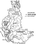
Study Basins within the Indian River Basin, 1989 to 1991
This map from the U. S. Geological Survey Water Resources Investigation Report number 97-4011, Rainfall and Freshwater Discharge in the Indian River Basin, shows the location of gaged and ungaged drainage basins within the Indian River Basin, includi...

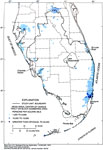
Population Density in South Florida, 1990
This map from the U. S. Geological Survey Circular 1134, The South Florida Environment, shows the population density in south Florida based on 1990 Census data. The map shows the mean areal center of census tract or block numbering area in terms of p...

Major Wastewater Facilities and Landfills in South Florida, 1990 to 1994
This map from the U. S. Geological Survey Circular 1134, The South Florida Environment, shows the location of major wastewater facilities and landfills in south Florida based on Florida Department of Environmental Protection data from 1990 to 1994. T...

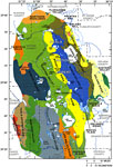
Physiography of the Ocala National Forest and Lake County Region, 1990 to 1999
This map from the U. S. Geological Survey Water Resources Investigation Report number 01-4008, Ground-Water Quality of the Surficial Aquifer System and the Upper Floridan Aquifer, Ocala National Forest and Lake County, 1990-99, shows the physiography...

Springs in the Ocala National Forest and Lake County, 1990 to 1999
This map from the U. S. Geological Survey Water Resources Investigation Report number 01-4008, Ground-Water Quality of the Surficial Aquifer System and the Upper Floridan Aquifer, Ocala National Forest and Lake County, 1990-99, shows the location of ...

Concentrations of Calcium, Magnesium, and Sodium in Groundwater from the Surficial Aquifer of Ocala National Forest and Lake County, 1990 to 1999
This map from the U. S. Geological Survey Water Resources Investigation Report number 01-4008, Ground-Water Quality of the Surficial Aquifer System and the Upper Floridan Aquifer, Ocala National Forest and Lake County, 1990-99, shows the relative per...

Concentrations of Bicarbonate, Sulfate, and Chloride in Groundwater from the Surficial Aquifer of Ocala National Forest and Lake County, 1990 to 1999
This map from the U. S. Geological Survey Water Resources Investigation Report number 01-4008, Ground-Water Quality of the Surficial Aquifer System and the Upper Floridan Aquifer, Ocala National Forest and Lake County, 1990-99, shows the relative per...

Concentrations of Total Dissolved Solids in Groundwater from the Surficial Aquifer of Ocala National Forest and Lake County, 1990 to 1999
This map from the U. S. Geological Survey Water Resources Investigation Report number 01-4008, Ground-Water Quality of the Surficial Aquifer System and the Upper Floridan Aquifer, Ocala National Forest and Lake County, 1990-99, shows the concentratio...

Concentrations of Nitrate in Groundwater from the Surficial Aquifer of Ocala National Forest and Lake County, 1990 to 1999
This map from the U. S. Geological Survey Water Resources Investigation Report number 01-4008, Ground-Water Quality of the Surficial Aquifer System and the Upper Floridan Aquifer, Ocala National Forest and Lake County, 1990-99, shows the concentratio...

Concentrations of Calcium, Magnesium, and Sodium in Groundwater from the Upper Floridan Aquifer of Ocala National Forest and Lake County, 1990 to 1999
This map from the U. S. Geological Survey Water Resources Investigation Report number 01-4008, Ground-Water Quality of the Surficial Aquifer System and the Upper Floridan Aquifer, Ocala National Forest and Lake County, 1990-99, shows the relative per...

Concentrations of Bicarbonate, Sulfate, and Chloride in Groundwater from the Upper Floridan Aquifer of Ocala National Forest and Lake County, 1990 to 1999
This map from the U. S. Geological Survey Water Resources Investigation Report number 01-4008, Ground-Water Quality of the Surficial Aquifer System and the Upper Floridan Aquifer, Ocala National Forest and Lake County, 1990-99, shows the relative per...

Concentrations of Total Dissolved Solids in Groundwater from the Upper Floridan Aquifer of Ocala National Forest and Lake County, 1990 to 1999
This map from the U. S. Geological Survey Water Resources Investigation Report number 01-4008, Ground-Water Quality of the Surficial Aquifer System and the Upper Floridan Aquifer, Ocala National Forest and Lake County, 1990-99, shows the concentratio...

Concentrations of Sulfate in Groundwater from the Upper Floridan Aquifer of Ocala National Forest and Lake County, 1990 to 1999
This map from the U. S. Geological Survey Water Resources Investigation Report number 01-4008, Ground-Water Quality of the Surficial Aquifer System and the Upper Floridan Aquifer, Ocala National Forest and Lake County, 1990-99, shows the concentratio...

Concentrations of Chloride in Groundwater from the Upper Floridan Aquifer of Ocala National Forest and Lake County, 1990 to 1999
This map from the U. S. Geological Survey Water Resources Investigation Report number 01-4008, Ground-Water Quality of the Surficial Aquifer System and the Upper Floridan Aquifer, Ocala National Forest and Lake County, 1990-99, shows the concentratio...

Concentrations of Calcium, Magnesium, and Sodium in Spring Water from the Upper Floridan Aquifer of Ocala National Forest and Lake County, 1990 to 1999
This map from the U. S. Geological Survey Water Resources Investigation Report number 01-4008, Ground-Water Quality of the Surficial Aquifer System and the Upper Floridan Aquifer, Ocala National Forest and Lake County, 1990-99, shows the relative per...

First Previous Next Last


  FL Maps > Region > 1950-1999
Site Map  

Maps ETC is a part of the Educational Technology Clearinghouse
Produced by the Florida Center for Instructional Technology © 2007
College of Education , University of South Florida